Prev: 10th ann. of the Az..ijan State Oil Fund (Azerbaijan)
Next: 10th Anniversary of the Baltic Chain (Lithuania)
Next: 10th Anniversary of the Baltic Chain (Lithuania)
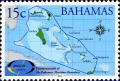
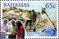
10th Anniversary of the Bahamas National Geographic Information System issue of Bahamas
|
Short desc: 10th Anniversary of the Bahamas National Geographic Information System
Issuer: Bahamas Date: 7/21/2014 Occasion: Bahamas National Geographic Information System opening Number/Year: 10 Consists of 4 stamps: (See stamps as list) 15c d=Maritime boundary 50c d=Hurricane distribution 1962-2012 65c d=Maritime boundary verification 70c d=Data collection on Inagua All are perf=13 Record of changes |
|