|
|
Name: map of South Pacific
Type: map
Appearing in designs:
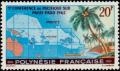
map of South Pacific & beach scene French Polynesia 7/18/1962 20fr issue=5th South Pacific Conference
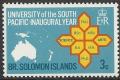
map of South Pacific & University Degrees (3 stamps of Solomon Islands, 1969)
map of South Pacific (1972 Gilbert & Ellice Islands) Gilbert & Ellice Islands 2/21/1972 3c issue=South Pacific Commission 25th
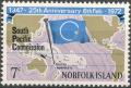
map of South Pacific (1972 Norfolk Island) Norfolk Island 2/6/1972 7c issue=South Pacific Commission 25th
Melanesian outrigger canoe & map of South Pacific Nauru 9/1/1975 20c issue=15th South Pacific Conference
Micronesian outrigger canoe & map of South Pacific Nauru 9/1/1975 20c issue=15th South Pacific Conference
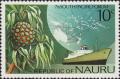
pandanus & ship & map of South Pacific Nauru 7/26/1976 10c issue=7th South Pacific Forum
Polynesian double hull canoe & map of South Pacific Nauru 9/1/1975 20c issue=15th South Pacific Conference
Polynesian outrigger canoe & map of South Pacific Nauru 9/1/1975 20c issue=15th South Pacific Conference
No synonyms.
Record of changes |
Wikipedia article |